Scenic Byway Strategic Plan Becomes a Reality
In March of this year, the MVHC completed its five-year Corridor Management Plan (CMP) update for the Maumee Valley Scenic Byway (MVSB). Established in 1998, the Ohio Scenic Byway Program is a grassroots effort to heighten awareness of our state’s cultural, historical, archeological, recreational, natural and scenic resources. Ohio’s Scenic Byway program is administered by the Ohio Department of Transportation (ODOT) in partnership with local communities, organizations and government agencies. Its purpose is to promote travel and recreation and to enhance and provide stewardship for the intrinsic features that distinguish the highways, roads and streets that comprise Ohio’s designated byway corridors.
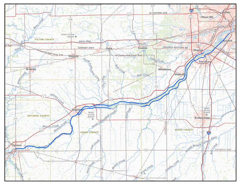
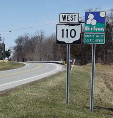
The MVSB is one of 27 byways in Ohio, and was designated through the efforts of the MVHC and local stakeholders. The nearly 90-mile route begins on the north side of the Maumee River in the City of Defiance at the intersection of State Route 15 and River Drive (CR 424). The byway follows River Road eastward through Napoleon, Waterville and into Maumee to the site of the former British Fort Miamis (an affiliated site of the National Park Service), where it ends. On the south side of the Maumee, the byway starts at Napoleon on State Route 110 and continues on State Route 65 through the historic towns of Grand Rapids, Perrysburg, and Rossford, ending at I-75.
On April 16 the CMP update was accepted by ODOT, signifying our full compliance with this requirement of the Program. The CMP is a written docu-ment that serves as a record of a scenic byway’s development as well as the plan by which the scenic byway is implemented and then maintained and enhanced indefinitely. The CMP identifies six goals over the next five years.
Goal 1: Educate the public about the unique intrinsic qualities of the Maumee River Valley. Updating existing brochures and promotional materials will be an immediate first action to meet this goal, but we’ll also be looking to improve our website presence as well as developing digital applications for the more tech-savvy visitors and users. We would like to bring all this together by developing an integrated signage and media system of local heritage features.
Goal 2: Advocate for the continued development of a multi-modal byway corridor. The Ohio Scenic Byway program emphasizes vehicular travel, but we well know that the Maumee Valley can also be enjoyed by foot, bicycle, or boat. By reaching out to transportation/travel advisors, and with input from local stakeholders, we will develop an action plan to make the byway a major destination for all types of travel, with a strategy for advocacy and implementation.
Goal 3: Encourage organizations, business and communities to view the byway (and its intrinsic qualities) as a tool for economic development in the region. With the help of local universities, other byway organizations, and experts in the field, we hope to compile data on the economic impact of recreation/heritage/eco-tourism, and distribute the results through a variety of media and outreach.
Goal 4: Work with city, village, and township planning/zoning commissions and other stakeholders to preserve the uniqueness of the byway and to garner more involvement in the byway. We will identify the stakeholders in the MVSB with an interest regional land use, share information about
incentive/recognition programs, provide updates on economic studies, and meet annually for a “state of the byway” meeting. To enhance public access to the byway’s attractions, we will help jurisdictions to evaluate current access, site limitations, and signage for these attractions.
Goal 5: Promote community pride in the appearance of the MVSB. We’ll work with municipalities and local historical societies to install interpretive signage at key locations along the Byway, and to develop an awards program to recognize beautification efforts or preservation successes.
Goal 6: Extend the existing Byway east to Toledo and west to the Indiana state line, with no gaps. It’s been on our plate for several years to capture the entire Maumee Valley in the Byway, as it tells a complete and uninterrupted narrative of our region’s natural and historical development.
As part of the MVHC’s overarching mission, the Scenic Byway Committee will specifically focus on management, coordination, promotion, and development of byway initiatives in the corridor. Anyone interested in serving on the Byway Committee or contributing in other ways is invited to contact Maura Johnson at 419-278-0773 or [email protected].
For more information about the Ohio Scenic Byway program, go online to
https://www.transportation.ohio.gov/wps/portal/gov/odot/programs/ohio-byways-program.
